Ariel Survey of Oklahoma State Highway 21, 1955-11-17
Scope and Contents
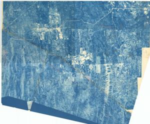
The document represents a map item is an aerial photograph of Oklahoma State Highway 21 near Bethel, McCurtain County, Oklahoma. The photograph shows the roadways and topography of the vicinity. Annotated on item in two separate places are dashed lines (red, pencil) connecting State Highway 21. Both annotated lines are labeled "Possible Location". Photograph (aerial; topographic map; blueprint); 49 3/8 x 43 inches (pentagonal); BQJ-4N-173; BQJ-4N-116; Annotated and Inscribed (red, pencil); Inscribed (bottom, center; red, pencil): Completed Survey from Broken Bow North to Approximately 3.1 Mile South of this point.
Dates
- Creation: 1955-11-17
Creator
- From the Collection: Kerr, Robert Samuel, United States Senator from Oklahoma (1949-1963); 12th Governor of Oklahoma (1943-1947), 1896-1963 (Person)
Language of Materials
English
Conditions Governing Access:
Certain series of this collection are stored off-site and require prior notice to access. If you wish to view these materials, please contact the Congressional Archives staff to arrange an appointment.
The following series are stored off-site: Clippings and Invitations.
Full Extent
1 pages
Abstract
84th (1955-1957)
Repository Details
Part of the Carl Albert Center Congressional and Political Collections Repository