Alaska, 1955
Scope and Contents
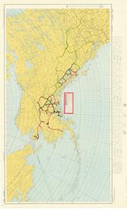
The document represents a map item is a topographic map of Alaska which encompasses the region and includes a portion of Russia, most of Canada, and part of the United States. This map features annotations of existing and proposed highways in Alaska and Canada as well as the route of the proposed Southeast Alaska Ferry. Annotations are color-coded in key adhered to center of map. Topographic map (regional; Lambert Conformal Conic Projection; gel-lithograph); 27 5/8 x 45 3/16 inches; 3069; Annotations (color-coded; various colors) of existing and proposed highways.
Dates
- Creation: 1955
Creator
- From the Collection: Kerr, Robert Samuel, United States Senator from Oklahoma (1949-1963); 12th Governor of Oklahoma (1943-1947), 1896-1963 (Person)
Language of Materials
English
Conditions Governing Access:
Certain series of this collection are stored off-site and require prior notice to access. If you wish to view these materials, please contact the Congressional Archives staff to arrange an appointment.
The following series are stored off-site: Clippings and Invitations.
Full Extent
1 pages
Abstract
84th (1955-1957)
Repository Details
Part of the Carl Albert Center Congressional and Political Collections Repository