Plans of Proposed Signing-Striping-Delineation, Federal Aid Project No. I-44-2(27)091, Interstate-44, Control Section No. 72-78 and 66-30, 1960-05-05
Scope and Contents
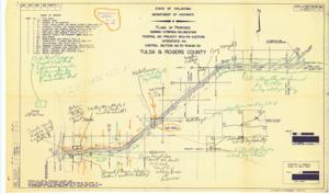
The document represents a plan item is an index map of the Federal Aid Project No. I-44-2(27)091 in Tulsa and Rogers Counties, Oklahoma during fiscal year 1959. This map features the project's proposed overall site plan for signing, striping, and delineation. According to the "Index of Sheets" included on item, this map is the "Title Sheet" as it is Sheet No. 1 of 41. "PRELIMINARY" was written on the original plan used to create this print. Index map (site plan; diazotype, blueline print); 21 11/16 x 36 7/16 inches; Stamped (blue, ink): Ernest E. Clulow, Jr., Attorney at Law, Mayo Building, Tulsa, Oklahoma; Dated (stamp; blue, ink): May 5 1960; Annotated and Inscribed (oil pastels, orange, green, black) notes and arrows.
Dates
- Creation: 1960-05-05
Creator
- From the Collection: Kerr, Robert Samuel, United States Senator from Oklahoma (1949-1963); 12th Governor of Oklahoma (1943-1947), 1896-1963 (Person)
Language of Materials
English
Conditions Governing Access:
Certain series of this collection are stored off-site and require prior notice to access. If you wish to view these materials, please contact the Congressional Archives staff to arrange an appointment.
The following series are stored off-site: Clippings and Invitations.
Full Extent
1 pages
Abstract
86th (1959-1961)
Repository Details
Part of the Carl Albert Center Congressional and Political Collections Repository