Isohyetal Map: Storm of 13-19 May 1951 (Preliminary Storm Study Investigation), 1951-08-01
Scope and Contents
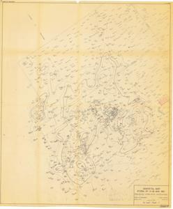
The document represents a map item is a weather map of precipitation from a May 13-19, 1951 storm, which occurred predominantly in the Texas panhandle and western half of Oklahoma. This map indicates and plots the connecting areas of equal rainfall with lines. Numbers 1 through 5 are inscribed and circled on the map in red pencil as is the key. Key identifies each number as a creek: (1) Mill Creek, (2) East Creek, (3) Cloud Creek, (4) Barnite Creek, (5) Sandstone Creek. Weather map (diazotype, blackline print); 41 7/8 x 34 3/4 inches; Inscribed (bottom, right corner; pencil): Attachment 2; Inscribed (numbers, creeks; red, pencil); Shading (green, pencil; crosshatch) in five small areas near noted creeks; Annotations (red, pencil; underlined) for Roff, Paoli, Cloud Chief, Anthon, and Cheyenne, Oklahoma.
Dates
- Creation: 1951-08-01
Creator
- From the Collection: Kerr, Robert Samuel, United States Senator from Oklahoma (1949-1963); 12th Governor of Oklahoma (1943-1947), 1896-1963 (Person)
Language of Materials
English
Conditions Governing Access:
Certain series of this collection are stored off-site and require prior notice to access. If you wish to view these materials, please contact the Congressional Archives staff to arrange an appointment.
The following series are stored off-site: Clippings and Invitations.
Full Extent
1 pages
Abstract
82nd (1951-1953)
Repository Details
Part of the Carl Albert Center Congressional and Political Collections Repository