Isohyetal Map: Storm of 9-13 July 1951 (MR 10-2), 1951-08-24
Scope and Contents
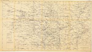
The document represents a map item is a weather map of precipitation from a July 9-13, 1951 storm in the southern portion of the Missouri River Basin. This map indicates and plots the connecting areas of equal rainfall with lines. Weather map (diazotype, blackline print); 28 x 49 7/8 inches; Inscribed (bottom, right corner; pencil): Attachment 4; Inscribed (verso top, center; pencil): #102a; Shading (green, pencil; crosshatch) in portion of sections 7f, 8f, 9g, 10g, top right corner of 9h; Annotations (red, pencil; underlined) for Diamond Springs and Iola, Kansas and Miami, Oklahoma.
Dates
- Creation: 1951-08-24
Creator
- From the Collection: Kerr, Robert Samuel, United States Senator from Oklahoma (1949-1963); 12th Governor of Oklahoma (1943-1947), 1896-1963 (Person)
Language of Materials
English
Conditions Governing Access:
Certain series of this collection are stored off-site and require prior notice to access. If you wish to view these materials, please contact the Congressional Archives staff to arrange an appointment.
The following series are stored off-site: Clippings and Invitations.
Full Extent
1 pages
Abstract
82nd (1951-1953)
Repository Details
Part of the Carl Albert Center Congressional and Political Collections Repository