Arkansas River Basin Grand (Neosho) River, Index Map - Digitized, November, 1944
Scope and Contents
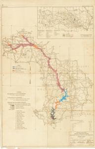
The document represents a map This item is an index map of the Grand (Neosho) River, which runs through Oklahoma, Kansas, Missouri, and Arkansas in the Arkansas River Basin. The physical map appears to be from November 1944 and was repurposed in 1951 to document and visualize the statuses of the reservoirs in comparison to the extent of the July 1951 flood. A new legend was printed on the map and color-coded by hand. Included with the map of the Grand River is a vicinity map of the Arkansas River Basin. Created by the United States Engineering Office, Tulsa, Oklahoma in November 1944 Drawn by CWS Traced by CWS Checked by HHP Revised January 15, 1945 to "accompany the survey report" Index map (topographic map; diazotype, light brown); 41 3/4 x 26 3/4 inches; Annotations (hand-colored; color-coded; pink, pencil; blue, brown, orange, ink/paint); Inscribed (left of legend; pencil): partial; Inscribed (bottom, right corner): Sheet No. 1; In 1 Sheet; Inscribed (bottom, right corner): To accompany Survey Report dated January 15, 1945; Inscribed (bottom, right corner): G.N.8/1A.
Dates
- Creation: November, 1944
Creator
- From the Collection: Kerr, Robert Samuel, United States Senator from Oklahoma (1949-1963); 12th Governor of Oklahoma (1943-1947), 1896-1963 (Person)
Language of Materials
English
Conditions Governing Access:
Certain series of this collection are stored off-site and require prior notice to access. If you wish to view these materials, please contact the Congressional Archives staff to arrange an appointment.
The following series are stored off-site: Clippings and Invitations.
Full Extent
1 pages
Abstract
78th (1943-1945); 79th (1945-1947)
Topical
Repository Details
Part of the Carl Albert Center Congressional and Political Collections Repository