City of Oklahoma City General Plan: Oklahoma City Floodway, 1951-11
Scope and Contents
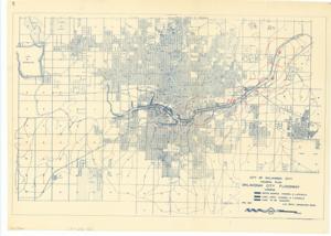
The document represents a plan item is a map and area plan of Oklahoma City featuring the Oklahoma City Floodway project along the Canadian River. The numbered circles along the floodway are inferred to correspond to photographs given the inscribed message on verso. Area plan (orthographic projection; road map; positive blueprint); 21 1/4 x 29 1/2 inches; Annotated (seven circles; red marker); Numbers Inscribed (within six circles; red marker): 1; 3; 4; 6; 7; 8; Numbers Inscribed (within one circle; red marker): 5&2; Inscribed (verso; pencil): KEY MAP TO PICTURES.
Dates
- Creation: 1951-11
Creator
- From the Collection: Kerr, Robert Samuel, United States Senator from Oklahoma (1949-1963); 12th Governor of Oklahoma (1943-1947), 1896-1963 (Person)
Language of Materials
English
Conditions Governing Access:
Certain series of this collection are stored off-site and require prior notice to access. If you wish to view these materials, please contact the Congressional Archives staff to arrange an appointment.
The following series are stored off-site: Clippings and Invitations.
Full Extent
1 pages
Abstract
82nd (1951-1953)
Repository Details
Part of the Carl Albert Center Congressional and Political Collections Repository