Principal Waterways of the United States, 1942
Scope and Contents
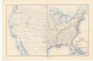
The document represents a map item is a national map depicting all of the waterways improved by the United States and those, which are state, foreign, and privately-owned as well as the waterways that are projected but not completed by either group. Featured on the map is the projected waterway in Texas, authorized by the 1945 Rivers and Harbors Act. Historical map (national; gel-lithograph); 20 1/2 x 31 inches; Stamped (red): 1945 Rivers and Harbors Act; Annotation (stamped; red ink) of projected US waterway 9 to 12 feet deep from Galveston to Fort Worth Texas.
Dates
- Creation: 1942
Creator
- From the Collection: Kerr, Robert Samuel, United States Senator from Oklahoma (1949-1963); 12th Governor of Oklahoma (1943-1947), 1896-1963 (Person)
Language of Materials
English
Conditions Governing Access:
Certain series of this collection are stored off-site and require prior notice to access. If you wish to view these materials, please contact the Congressional Archives staff to arrange an appointment.
The following series are stored off-site: Clippings and Invitations.
Full Extent
1 pages
Abstract
79th (1945-1947)
Repository Details
Part of the Carl Albert Center Congressional and Political Collections Repository