Corps of Engineers Division and District Boundaries for River and Harbor and Flood Control, January 1, 1949
Scope and Contents
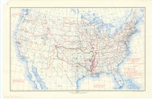
The document represents a map map has been annotated to change the division or district boundaries around the State of Oklahoma. Additionally, a dark dot has been annotated over Oklahoma City, which may indicate a District Headquarters location. A red dot has been annotated over Fort Worth, Texas. Historical map (national; gel-lithograph); 20 7/16 x 30 15/16 inches; Annotations (red, brown) around Oklahoma and on cities.
Dates
- Creation: January 1, 1949
Creator
- From the Collection: Kerr, Robert Samuel, United States Senator from Oklahoma (1949-1963); 12th Governor of Oklahoma (1943-1947), 1896-1963 (Person)
Language of Materials
English
Conditions Governing Access:
Certain series of this collection are stored off-site and require prior notice to access. If you wish to view these materials, please contact the Congressional Archives staff to arrange an appointment.
The following series are stored off-site: Clippings and Invitations.
Full Extent
1 pages
Abstract
81st (1949-1951)
Repository Details
Part of the Carl Albert Center Congressional and Political Collections Repository