Le Flore County, Oklahoma, 1951-01-11
Scope and Contents
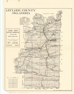
The document represents a map item is a topographic map of Le Flore County, Oklahoma and features rivers, streams, mountains, and the Wister Reservoir. Map also features the locations of gas wells and dry holes as well as the divisions of section, township, and range for the county. Item accompanied letter from Riley Smith to Don McBride dated January 11, 1951 pertaining to a block of land Smith thinks is for sale and believes is ideal for cattle. This letter corresponds to the annotations on the map. Topographic map; 22 x 17 inches; Shading (red, pencil) of Sections 9, 10, and 13-24, T2N, R24E, which are west of Big Cedar; Inscribed (bottom, right corner): Gallup Map and Stationery Co. K.C. MO. MAP No.-40-450; Inscribed (verso; top, left corner): Encl. w/ corres. Don McBride to Riley Smith, 1951. Industry-Coal.
Dates
- Creation: 1951-01-11
Creator
- From the Collection: Kerr, Robert Samuel, United States Senator from Oklahoma (1949-1963); 12th Governor of Oklahoma (1943-1947), 1896-1963 (Person)
Language of Materials
English
Conditions Governing Access:
Certain series of this collection are stored off-site and require prior notice to access. If you wish to view these materials, please contact the Congressional Archives staff to arrange an appointment.
The following series are stored off-site: Clippings and Invitations.
Full Extent
1 pages
Abstract
82nd (1951-1953)
Repository Details
Part of the Carl Albert Center Congressional and Political Collections Repository