Ward and Precinct Map: Oklahoma City, Oklahoma, 1953-01-01 - 1953-12-31
Item — Box: OS 3
Identifier: CAC_CC_031_14_0000_3_127
Ward and Precinct Map: Oklahoma City, Oklahoma, 1953-01-01 - 1953-12-31
Scope and Contents
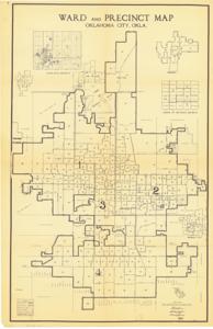
The document represents a map item is a map of the wards and precincts of Oklahoma City, Oklahoma and includes individual maps of Edmond, Midwest City, Warr Acres, and Del City as well as vicinity maps of the legislative and justice of the peace districts. Historical map (diazotype, blackline print); 14 x 8 1/2 inches.
Dates
- Creation: 1953-01-01 - 1953-12-31
Creator
- From the Collection: Kerr, Robert Samuel, United States Senator from Oklahoma (1949-1963); 12th Governor of Oklahoma (1943-1947), 1896-1963 (Person)
Language of Materials
From the Collection:
English
Conditions Governing Access:
Certain series of this collection are stored off-site and require prior notice to access. If you wish to view these materials, please contact the Congressional Archives staff to arrange an appointment.
The following series are stored off-site: Clippings and Invitations.
Full Extent
1 pages
Abstract
83rd (1953-1955)
Repository Details
Part of the Carl Albert Center Congressional and Political Collections Repository