Ward and Precinct Map: Oklahoma City, Oklahoma, 1953-01-01 - 1953-12-31
Item — Box: OS 3
Identifier: CAC_CC_031_14_0000_3_126
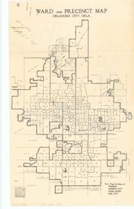
Ward and Precinct Map: Oklahoma City, Oklahoma, 1953-01-01 - 1953-12-31
Scope and Contents
The document represents a map item is a map of the wards and precincts of Oklahoma City. Oklahoma. Map verso features individual maps of Edmond, Midwest City, Warr Acres, and Del City. This item is a smaller, dual-sided leaflet version of Kerr, Maps, Item 127. Historical map; 14 x 8 1/2 inches.
Dates
- Creation: 1953-01-01 - 1953-12-31
Creator
- From the Collection: Kerr, Robert Samuel, United States Senator from Oklahoma (1949-1963); 12th Governor of Oklahoma (1943-1947), 1896-1963 (Person)
Language of Materials
From the Collection:
English
Conditions Governing Access:
Certain series of this collection are stored off-site and require prior notice to access. If you wish to view these materials, please contact the Congressional Archives staff to arrange an appointment.
The following series are stored off-site: Clippings and Invitations.
Full Extent
1 pages
Abstract
83rd (1953-1955)
Repository Details
Part of the Carl Albert Center Congressional and Political Collections Repository