Kiowa County, 1956-06-13
Scope and Contents
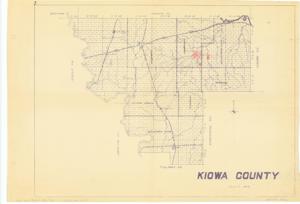
The document represents a map item is a section, township, and range map of Kiowa County, Oklahoma. Map features railroads and various creeks and waterways including a small portion of the Washita River. Indicated on the map are sections and portions of sections, which are colored red and numbered. These annotated sections represent the locations of land leased to the Amis Construction Co. by the "Indians in Kiowa County through the Bureau of Indian Affairs located at the Anadarko, Oklahoma office..." Sections 14, 13, 23, and 24, T6N, R16W are inscribed (red, pencil): 1. The SE 1/4 Section 20, T6N, R15W is inscribed (red, pencil): 2. The NE 1/4 Section 20, T6N, R15W is inscribed (red, pencil): 3. The NE 1/4 Section 36, T6N, R16W is inscribed (red, pencil): 4. The SE 1/16 Section 30, T7N, R15W is colored and not numbered. Map (diazotype, blueline print); 18 3/8 x 26 11/16 inches; Annotations (red, pencil): shading sections and portions of sections; Inscribed (bottom, right corner): Kiowa No. 62; Inscribed (verso, bottom, left corner): Enclosed with corres. of Amis Construction Co. in Clinton Sherman Air Force Base 1955-1956 folder. Military correspondence relating to federal installations.
Dates
- Creation: 1956-06-13
Creator
- From the Collection: Kerr, Robert Samuel, United States Senator from Oklahoma (1949-1963); 12th Governor of Oklahoma (1943-1947), 1896-1963 (Person)
Language of Materials
English
Conditions Governing Access:
Certain series of this collection are stored off-site and require prior notice to access. If you wish to view these materials, please contact the Congressional Archives staff to arrange an appointment.
The following series are stored off-site: Clippings and Invitations.
Full Extent
1 pages
Abstract
84th (1955-1957)
Repository Details
Part of the Carl Albert Center Congressional and Political Collections Repository