Zoning and Land Use Plan, Will Rogers Field Area - Digitized, 1960-11-01 - 1961-04-19
Scope and Contents
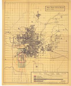
The document represents a plan item is a zoning and land use map and area plan of the Will Rogers Field Area prepared by Hudgins, Thompson, Ball and Associates Architects and Engineers. The map depicts the recommended boundary to be owned by the City (red outline), the area unsuited for residential development due to high-level jet aircraft noises (green crosshatch), and the areas recommended by the Oklahoma City Chamber of Commerce as unnecessary or undesirable for residential use (orange crosshatch). Original map print is of Oklahoma City and Vicinity and was prepared by the Oklahoma City Engineering Department, W.W. Baker (City Engineer), Sheldon L. Stirling (City Manager). Zoning, land use map (area plan; diazotype, blackline print); 26 1/2 x 21 3/8 inches; Annotated (red, pencil) outlines; Annotated (green pencil) crosshatch; Annotated (orange, pencil) crosshatch, "A", "B"; Inscribed (top, right corner; pencil): Corre. From Hudgins, Thompson, Ball and Associates; 9; 4/20/61; FAA Zoning; FHA.
Dates
- Creation: 1960-11-01 - 1961-04-19
Creator
- From the Collection: Kerr, Robert Samuel, United States Senator from Oklahoma (1949-1963); 12th Governor of Oklahoma (1943-1947), 1896-1963 (Person)
Language of Materials
English
Conditions Governing Access:
Certain series of this collection are stored off-site and require prior notice to access. If you wish to view these materials, please contact the Congressional Archives staff to arrange an appointment.
The following series are stored off-site: Clippings and Invitations.
Full Extent
1 pages
Abstract
86th (1959-1961); 87th (1961-1963)
Repository Details
Part of the Carl Albert Center Congressional and Political Collections Repository