Ouachita National Forest, Arkansas and Oklahoma, (Kiamichi Division) Indian Meridian, 1956-01-01 - 1956-12-31
Scope and Contents
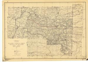
The document represents a map item is a forestry map of the Oklahoma portion of the Ouachita National Forest. Map features two annotations. The first annotation in red pencil traces a length of road and is labeled with the inscription: Road #1. The second annotation in green pencil traces the length of two intersecting roads and is labeled with the inscription: Road M 2. This map was "Compiled at Regional Office, Washington, 1930, from U.S.G.S., G.L.O., Forest Service, and other surveys by H.S. Meekham," "Traced by C.B. Noyes, 1931," and "Rev. by M.E.P. 1956." Forestry map (polyconic projection; diazotype, blackline print); 18 3/4 x 26 3/8 inches; Annotated (red, pencil) length of "Road #1"; Annotated (green, pencil) length of "Road M 2".
Dates
- Creation: 1956-01-01 - 1956-12-31
Creator
- From the Collection: Kerr, Robert Samuel, United States Senator from Oklahoma (1949-1963); 12th Governor of Oklahoma (1943-1947), 1896-1963 (Person)
Language of Materials
English
Conditions Governing Access:
Certain series of this collection are stored off-site and require prior notice to access. If you wish to view these materials, please contact the Congressional Archives staff to arrange an appointment.
The following series are stored off-site: Clippings and Invitations.
Full Extent
1 pages
Abstract
84th (1955-1957)
Repository Details
Part of the Carl Albert Center Congressional and Political Collections Repository