Le Flore County, Oklahoma, General Highway Map - Digitized, 1954
Scope and Contents
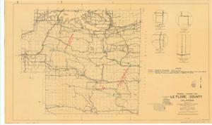
The document represents a map item is a map of the southern half of Le Flore County in Oklahoma and depicts various roadways, highways, buildings, residences, waterways, and landforms. Map features annotations and inscriptions pertaining to proposed construction, grading, and surfacing. "Proposed Construction Item" "(1)" and "(2)" are inscribed and annotated with red pencil. Green pencil annotations indicate roads for grading by U.S.E.D. Yellow pencil annotations indicate roads for grading and surfacing under Project F-116(4) and F-116(5). Created by the Oklahoma Department of Highways Department of Statistics in Cooperation with the Department of Commerce Bureau of Public Roads Topographic map (conic projection; diazotype, blackline print); 18 x 30 1/8 inches; Inscribed (bottom, left corner): Le Flore No. 2; Inscribed (bottom, right corner): Sheet 2 of 2 Sheets; Inscribed (bottom, right corner): General Highway Map Le Flore County Oklahoma 40.
Dates
- Creation: 1954
Creator
- From the Collection: Kerr, Robert Samuel, United States Senator from Oklahoma (1949-1963); 12th Governor of Oklahoma (1943-1947), 1896-1963 (Person)
Language of Materials
English
Conditions Governing Access:
Certain series of this collection are stored off-site and require prior notice to access. If you wish to view these materials, please contact the Congressional Archives staff to arrange an appointment.
The following series are stored off-site: Clippings and Invitations.
Full Extent
1 pages
Abstract
83rd (1953-1955)
Repository Details
Part of the Carl Albert Center Congressional and Political Collections Repository