Map of Oklahoma's State Highway System, 1950
Scope and Contents
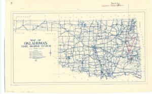
The document represents a map item is a map of the State of Oklahoma that depicts the state's highway system. Map features annotations and inscriptions of "Proposed Road, Red Oak to Talihina." The location points of the cities are annotated as dots (black, pen) and inscribed (black, pen) with their city names, Red Oak and Talihina. The proposed road is annotated as a line (red, pencil). Map (diazotype, blueline print); 14 x 22 inches; Inscribed (top, right; black, pen): Proposed Road, Red Oak to Talihina; Annotated (red, pencil) arrow pointing to further annotations and inscriptions; Inscribed (reverse; pencil): Indian road.
Dates
- Creation: 1950
Creator
- From the Collection: Kerr, Robert Samuel, United States Senator from Oklahoma (1949-1963); 12th Governor of Oklahoma (1943-1947), 1896-1963 (Person)
Language of Materials
English
Conditions Governing Access:
Certain series of this collection are stored off-site and require prior notice to access. If you wish to view these materials, please contact the Congressional Archives staff to arrange an appointment.
The following series are stored off-site: Clippings and Invitations.
Full Extent
1 pages
Abstract
81st (1949-1951)
Repository Details
Part of the Carl Albert Center Congressional and Political Collections Repository