State of Oklahoma Department of Highways Route Map of S.H. 21 and Future US 59 from Broken Bow northerly by Smithville to Kiamichi Mountain in McCurtain and Le Flore Counties, 1956-02-09
Scope and Contents
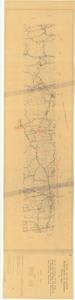
The document represents a map item is a section of map in Le Flore and McCurtain Counties (T3N, R23E to T7S, R26E). Map is annotated (red, pencil) in the places, two of which are inscribed "Possible Location." Third annotation is inscribed "Completed survey on this section." Topographic map (diazotype); 10 7/8 x 46 inches; Annotations (red, pencil).
Dates
- Creation: 1956-02-09
Creator
- From the Collection: Kerr, Robert Samuel, United States Senator from Oklahoma (1949-1963); 12th Governor of Oklahoma (1943-1947), 1896-1963 (Person)
Language of Materials
English
Conditions Governing Access:
Certain series of this collection are stored off-site and require prior notice to access. If you wish to view these materials, please contact the Congressional Archives staff to arrange an appointment.
The following series are stored off-site: Clippings and Invitations.
Full Extent
1 pages
Abstract
84th (1955-1957)
Repository Details
Part of the Carl Albert Center Congressional and Political Collections Repository