Arkansas River Watersheds - Eufaula Dam and Reservoir, Reservoir Area - Digitized, 1945-04-03
Scope and Contents
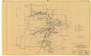
The document represents a map item is a map of the Eufaula Dam and Reservoir area and features flood control measures including the watershed of the reservoir and rivers. Power lines, railways, highways, and roads are depicted on map. This item was "To accompany Survey Report dated December 31, 1943." Map pertains to the "Arkansas River Watershed" of the "Arkansas River and Tributaries, Arkansas and Oklahoma." Serial 4732 Other identifying information - Appendix No. VII, Plate 40 Created by United States Engineer Office, Tulsa, Oklahoma on December 31, 1943 (original) Signed by Senior Engineer, Lt. Colonel Corps of Engineers Head Engineer, and the Colonel Corps of Engineers District Engineer Watershed map (topographic map; diazotype, blackline print); 20 3/4 x 33 1/4 inches; Inscribed (bottom, right corner): 32/160; Inscribed (bottom, right corner): Appendix No. VII Plate 40; Inscribed (reverse; pencil): Map Not For Release CB.
Dates
- Creation: 1945-04-03
Creator
- From the Collection: Kerr, Robert Samuel, United States Senator from Oklahoma (1949-1963); 12th Governor of Oklahoma (1943-1947), 1896-1963 (Person)
Language of Materials
English
Conditions Governing Access:
Certain series of this collection are stored off-site and require prior notice to access. If you wish to view these materials, please contact the Congressional Archives staff to arrange an appointment.
The following series are stored off-site: Clippings and Invitations.
Full Extent
1 pages
Abstract
79th (1945-1947)
Repository Details
Part of the Carl Albert Center Congressional and Political Collections Repository