Red River Basin: Flood Control and Navigation Projects - Digitized, 1956-02
Scope and Contents
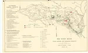
The document represents a map item is a map of the Red River Basin featuring various federally authorized flood control and navigation projects. All projects featured are enumerated on the map as well as color-coded based on its status. Completed projects are black; projects in progress are red; authorized projects are green. Authorized Federal Projects Created by the Corps of Engineers, United States Army Topographic map (hydrologic map; color); 17 x 27 5/8 inches.
Dates
- Creation: 1956-02
Creator
- From the Collection: Kerr, Robert Samuel, United States Senator from Oklahoma (1949-1963); 12th Governor of Oklahoma (1943-1947), 1896-1963 (Person)
Language of Materials
English
Conditions Governing Access:
Certain series of this collection are stored off-site and require prior notice to access. If you wish to view these materials, please contact the Congressional Archives staff to arrange an appointment.
The following series are stored off-site: Clippings and Invitations.
Full Extent
1 pages
Abstract
84th (1955-1957)
Repository Details
Part of the Carl Albert Center Congressional and Political Collections Repository