Tupelo Reservoir: Reservoir Area, Boggy Creek, Oklahoma, 1936-08-06
Scope and Contents
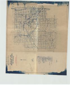
The document represents a map item is a map of the Boggy Creek, Oklahoma vicinity with a focus on the Tupelo Reservoir and Dam Site. Map features various symbols for dwellings, businesses, institutions, industry, and utility stations. Topographic map (watershed map; positive blue print); 17 7/8 x 21 1/4 inches; Stamped (bottom, right corner): Not Released for Publication or Reproduction; Inscribed (right side; pencil): Archives-U S Army Engineers.
Dates
- Creation: 1936-08-06
Creator
- From the Collection: Kerr, Robert Samuel, United States Senator from Oklahoma (1949-1963); 12th Governor of Oklahoma (1943-1947), 1896-1963 (Person)
Language of Materials
English
Conditions Governing Access:
Certain series of this collection are stored off-site and require prior notice to access. If you wish to view these materials, please contact the Congressional Archives staff to arrange an appointment.
The following series are stored off-site: Clippings and Invitations.
Full Extent
1 pages
Abstract
74th (1935-1937)
Repository Details
Part of the Carl Albert Center Congressional and Political Collections Repository