Oklahoma, 1921-1922
Scope and Contents
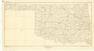
The document represents a map item is a topographic map of the State of Oklahoma, in which the data was compiled in 1921 and 1922 "based on State map by the General Land Office." Map features waterways, cities, towns, villages, counties, and railroads. Topographic map (polyconic projection); 18 1/16 x 33 inches; Shading and Enumeration (red, pencil) in eleven areas along Arkansas River; Shading (red, pencil) in single area along Canadian River; Inscribed and Shaded (bottom, right corner; red, pencil): Arthur City Area; Inscribed and Shaded (bottom, right corner; red, pencil): Boss Area; Inscribed and Shaded (bottom, right corner; red, pencil): Tom Area.
Dates
- Creation: 1921-1922
Creator
- From the Collection: Kerr, Robert Samuel, United States Senator from Oklahoma (1949-1963); 12th Governor of Oklahoma (1943-1947), 1896-1963 (Person)
Language of Materials
English
Conditions Governing Access:
Certain series of this collection are stored off-site and require prior notice to access. If you wish to view these materials, please contact the Congressional Archives staff to arrange an appointment.
The following series are stored off-site: Clippings and Invitations.
Full Extent
1 pages
Abstract
79th (1945-1947)
Repository Details
Part of the Carl Albert Center Congressional and Political Collections Repository