Sandstone Creek Watershed: Preliminary Work Plan for Runoff and Waterflow Retardation and Soil Erosion Prevention - Digitized, 1950-09-11
Scope and Contents
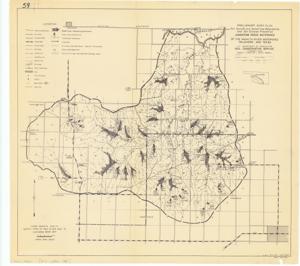
The document represents a plan item is a work plan and watershed map of the Sandstone Creek area of the Washita River Watershed in Oklahoma and Texas. The plan specifically identifies the "Upper Washita SCD-4" and the "North Fork of Red River SCD-8" as well as the "Cheyenne Work Unit." SCD denotes Soil Conservation District, and the number indicates the district number identifier. The original map and plan print is identifiable by the code: 4-R-7786. H. H. Bennett, chief, and Louis P. Merrill, Region 4 Director, of the Soil Conservation Service are identified on the plan. Area plan, watershed map (orthographic projection); 17 3/8 x 19 1/8 inches; Inscribed (bottom, right corner): L.A.K.; Inscribed (bottom, right corner): 4-R-7594.
Dates
- Creation: 1950-09-11
Creator
- From the Collection: Kerr, Robert Samuel, United States Senator from Oklahoma (1949-1963); 12th Governor of Oklahoma (1943-1947), 1896-1963 (Person)
Language of Materials
English
Conditions Governing Access:
Certain series of this collection are stored off-site and require prior notice to access. If you wish to view these materials, please contact the Congressional Archives staff to arrange an appointment.
The following series are stored off-site: Clippings and Invitations.
Full Extent
1 pages
Abstract
81st (1949-1951)
Repository Details
Part of the Carl Albert Center Congressional and Political Collections Repository