Multiple Purpose Plan for the development of Arkansas River and Tributaries - Digitized, 1936-1961
Scope and Contents
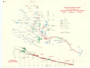
The document represents a map item is a map of the Arkansas River and its tributaries and reservoirs in Kansas, Oklahoma, and Arkansas. Reservoirs are color-coded based on their level of authorization and completion. Featured with the Arkansas River map is a profile of its navigation locks and dams titled: "A Water Stairway to Prosperity." On the reverse is information pertaining to the navigation projects of the Missouri River and inland waterways and their relation to the Arkansas River. Hydrologic map (broadside; profile, orthographic projection; color); 18 1/2 x 24 inches.
Dates
- Creation: 1936-1961
Creator
- From the Collection: Kerr, Robert Samuel, United States Senator from Oklahoma (1949-1963); 12th Governor of Oklahoma (1943-1947), 1896-1963 (Person)
Language of Materials
English
Conditions Governing Access:
Certain series of this collection are stored off-site and require prior notice to access. If you wish to view these materials, please contact the Congressional Archives staff to arrange an appointment.
The following series are stored off-site: Clippings and Invitations.
Full Extent
1 pages
Abstract
84th (1955-1957); 85th (1957-1959)
Repository Details
Part of the Carl Albert Center Congressional and Political Collections Repository