Wyandotte Quadrangle, Oklahoma-Missouri-Kansas, 1907
Scope and Contents
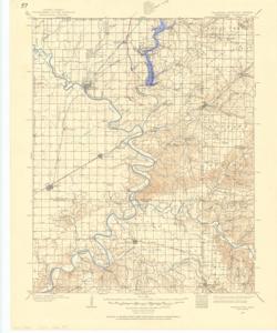
The document represents a map item is a topographic map of the Wyandotte Quadrangle in Oklahoma, which borders Missouri and Kansas. The map depicts the topography around Wyandotte, Oklahoma (N3630-W9430/30) in 1907. Survey for quadrangle conducted in 1906-1907. Map features roadways, railroads, drainage, waterways, farm units, cities, towns, and natural features. Topographic map (polyconic projection; color); 21 x 17 inches; Shading (blue, pen) along Spring River, starts N 3652/35 (T 24 N, R 24 E); Annotated (pink, pen) line through Ottawa; Annotated (pencil) water lines; Inscribed (pencil, ): Filtering Plant at N 3654/18-W 9446/32.
Dates
- Creation: 1907
Creator
- From the Collection: Kerr, Robert Samuel, United States Senator from Oklahoma (1949-1963); 12th Governor of Oklahoma (1943-1947), 1896-1963 (Person)
Language of Materials
English
Conditions Governing Access:
Certain series of this collection are stored off-site and require prior notice to access. If you wish to view these materials, please contact the Congressional Archives staff to arrange an appointment.
The following series are stored off-site: Clippings and Invitations.
Full Extent
1 pages
Abstract
83rd (1953-1955)
Repository Details
Part of the Carl Albert Center Congressional and Political Collections Repository