Arkansas River Watershed Oologah Reservoir, Reservoir Area - Digitized, 1956-09-12
Scope and Contents
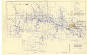
The document represents a map item is a map of the Verdigris River, Oklahoma, which includes watershed areas. This map was amended to depict the property of W. F. Graham, low/high water routes, and the relocation request by W. F. Graham. Map pertains to the Arkansas River Watershed Oologah Reservoir, Verdigris River, Oklahoma.This map is the second revision- first revision September 18, 1955 and second revision September 12, 1956. Watershed map (diazotype; blueline print); 20 3/4 x 33 inches; Inscribed (bottom, right corner): Sheet No. 1; In 1 Sheet.
Dates
- Creation: 1956-09-12
Creator
- From the Collection: Kerr, Robert Samuel, United States Senator from Oklahoma (1949-1963); 12th Governor of Oklahoma (1943-1947), 1896-1963 (Person)
Language of Materials
English
Conditions Governing Access:
Certain series of this collection are stored off-site and require prior notice to access. If you wish to view these materials, please contact the Congressional Archives staff to arrange an appointment.
The following series are stored off-site: Clippings and Invitations.
Full Extent
1 pages
Abstract
84th (1955-1957)
Repository Details
Part of the Carl Albert Center Congressional and Political Collections Repository