Forest Type Map of Oklahoma, 1940-12-12
Item — Box: OS 1
Identifier: CAC_CC_031_14_0000_1_47
Forest Type Map of Oklahoma, 1940-12-12
Scope and Contents
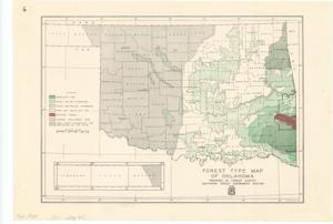
The document represents a map forestry map of Oklahoma featuring color and pattern-coded areas for types of trees as well as the Federal Shelterbelt Zone and areas under cooperative fire protection. Forestry map; 10 1/2 x 15 5/16 inches; Inscribed (top, left corner): 6.
Dates
- Creation: 1940-12-12
Creator
- From the Collection: Kerr, Robert Samuel, United States Senator from Oklahoma (1949-1963); 12th Governor of Oklahoma (1943-1947), 1896-1963 (Person)
Language of Materials
From the Collection:
English
Conditions Governing Access:
Certain series of this collection are stored off-site and require prior notice to access. If you wish to view these materials, please contact the Congressional Archives staff to arrange an appointment.
The following series are stored off-site: Clippings and Invitations.
Full Extent
1 pages
Abstract
76th (1939-1941)
Repository Details
Part of the Carl Albert Center Congressional and Political Collections Repository