Bank Stabilization and Channel Rectification: Short Mountain Dam Site to Wilson Rock, Oklahoma, Arkansas River, 1955-06-30
Scope and Contents
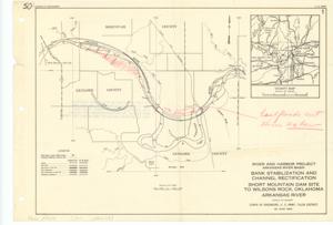
The document represents a plan area plan of the Bank Stabilization and Channel Rectification portion of the Arkansas River Basin's River and Harbor Project, which includes a vicinity map in the top, right corner. On reverse: Project. The bank stabilization and channel rectification in the reach between Short Mountain Dam site and Wilson Rock, Oklahoma, is an integral unit of the multiple-purpose plan authorized by the River and Harbor Act of July 24, 1946. Area plan (orthographic projection); 10 1/2 x 15 3/16 inches; Printed (top, right corner): 1; Inscribed (top, left corner): 50; Shading (red) south of the Arkansas River, north of 35 20N; Inscribed (right, center; red): [Last] floods cut thru Ox bow; Annotated (red) with an arrow pointing from words to area east of 94 40W and at 35 15N.
Dates
- Creation: 1955-06-30
Creator
- From the Collection: Kerr, Robert Samuel, United States Senator from Oklahoma (1949-1963); 12th Governor of Oklahoma (1943-1947), 1896-1963 (Person)
Language of Materials
English
Conditions Governing Access:
Certain series of this collection are stored off-site and require prior notice to access. If you wish to view these materials, please contact the Congressional Archives staff to arrange an appointment.
The following series are stored off-site: Clippings and Invitations.
Full Extent
1 pages
Abstract
84th (1955-1957)
Repository Details
Part of the Carl Albert Center Congressional and Political Collections Repository