Wichita Mountains Wildlife Refuge, 1940-1961
Scope and Contents
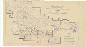
The document represents a map depicts the area expansion of Fort Sill into the Wichita Mountains Wildlife Refuge. Forestry map; 11 x 20 inches; 76 WIG 5; Inscribed (northern portion; red): BIG GAME PASTURE; Inscribed (southeast corner; red): FORT SILL; Annotation (southern; hand-shaded, red) expansion area; Inscribed (bottom, left corner; red): 10,700 Acres to be taken by the Army.
Dates
- Creation: 1940-1961
Creator
- From the Collection: Kerr, Robert Samuel, United States Senator from Oklahoma (1949-1963); 12th Governor of Oklahoma (1943-1947), 1896-1963 (Person)
Language of Materials
English
Conditions Governing Access:
Certain series of this collection are stored off-site and require prior notice to access. If you wish to view these materials, please contact the Congressional Archives staff to arrange an appointment.
The following series are stored off-site: Clippings and Invitations.
Full Extent
1 pages
Abstract
76th (1939-1941); 77th (1941-1943); 78th (1943-1945); 79th (1945-1947); 80th (1947-1949); 81st (1949-1951); 82nd (1951-1953); 83rd (1953-1955); 84th (1955-1957); 85th (1957-1959); 86th (1959-1961); 87th (1961-1963)
Repository Details
Part of the Carl Albert Center Congressional and Political Collections Repository