Authorized and Proposed Urban Highways, Oklahoma City Area - Digitized, 1940-1961
Scope and Contents
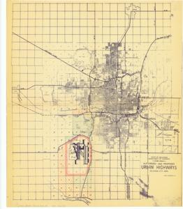
The document represents a map map was originally enclosed with a letter dating 1959 February 4 from Stanley Draper, Oklahoma City Chamber of Commerce, to Don McBride, Office of Robert S. Kerr. Map encompasses the Oklahoma City area Expressway System. Annotated in red is the Interstate sections of the System. The extension of the Interstate System connecting the Tinker area with the Will Rogers Field and the Crosstown Expressway (Interstate 40) is shaded in green. State of Oklahoma Department of Highways - Authorized and Proposed Urban Highways - Oklahoma City Area Created by Treat engineering Company Site plan; 21 x 17 13/16 inches; Annotated sections: (hand-shaded, in green); (outlined, red) around Rogers Field; (hand-shaded, orange-red) labeled A; (hand-shaded, orange-red) labeled B.
Dates
- Creation: 1940-1961
Creator
- From the Collection: Kerr, Robert Samuel, United States Senator from Oklahoma (1949-1963); 12th Governor of Oklahoma (1943-1947), 1896-1963 (Person)
Language of Materials
English
Conditions Governing Access:
Certain series of this collection are stored off-site and require prior notice to access. If you wish to view these materials, please contact the Congressional Archives staff to arrange an appointment.
The following series are stored off-site: Clippings and Invitations.
Full Extent
1 pages
Abstract
83rd (1953-1955)
Repository Details
Part of the Carl Albert Center Congressional and Political Collections Repository