Historical Map of Oklahoma, 1940-1961
Scope and Contents
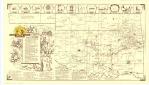
The document represents a map historical Map of Oklahoma with historical events, places, and cities marked on the map with words and pictures. Sixty historical events are listed at the bottom of the map and indexed with numbers which are labeled on the map. A brief timeline of Oklahoma and the territory to become Oklahoma is given. Pictorial map; 14 1/2 x 25 inches; Annotation (blue, circle) around Ft. Reno and annotation (blue, arrow) pointing at Ft. Reno.
Dates
- Creation: 1940-1961
Creator
- From the Collection: Kerr, Robert Samuel, United States Senator from Oklahoma (1949-1963); 12th Governor of Oklahoma (1943-1947), 1896-1963 (Person)
Language of Materials
English
Conditions Governing Access:
Certain series of this collection are stored off-site and require prior notice to access. If you wish to view these materials, please contact the Congressional Archives staff to arrange an appointment.
The following series are stored off-site: Clippings and Invitations.
Full Extent
1 pages
Abstract
84th (1955-1957)
Repository Details
Part of the Carl Albert Center Congressional and Political Collections Repository