Lawton County, Oklahoma, 1940-01-01 - 1961-12-31
Scope and Contents
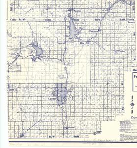
The document represents a map township and range map of Lawton County, Oklahoma with unique indications for featured roads and roadways as well as farm units, dwellings, and religious institutions. Land use map (diazotype, blueline print); 14 1/8 x 12 3/4 inches; Hand-shaded portions; Inscribed (bottom, left corner): Indian Land North and East of Cameron is shaded with pencil.
Dates
- Creation: 1940-01-01 - 1961-12-31
Creator
- From the Collection: Kerr, Robert Samuel, United States Senator from Oklahoma (1949-1963); 12th Governor of Oklahoma (1943-1947), 1896-1963 (Person)
Language of Materials
English
Conditions Governing Access:
Certain series of this collection are stored off-site and require prior notice to access. If you wish to view these materials, please contact the Congressional Archives staff to arrange an appointment.
The following series are stored off-site: Clippings and Invitations.
Full Extent
1 pages
Abstract
76th (1939-1941); 77th (1941-1943); 78th (1943-1945); 79th (1945-1947); 80th (1947-1949); 81st (1949-1951); 82nd (1951-1953); 83rd (1953-1955); 84th (1955-1957); 85th (1957-1959); 86th (1959-1961); 87th (1961-1963)
Repository Details
Part of the Carl Albert Center Congressional and Political Collections Repository