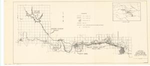
Fort Cobb Project, Initial Phase: General Land Map and Land Classification, 1951-04-10
Item — Box: OS 1
Identifier: CAC_CC_031_14_0000_1_6
Fort Cobb Project, Initial Phase: General Land Map and Land Classification, 1951-04-10
Scope and Contents
The document represents a map washita River Sub-Basin, Oklahoma. Aqueduct, Municipal Water Supply Pipe Line to Anadarko and Chickasha. Land use map; 10 1/2 x 23 1/2 inches; DWG. 480-514-380.
Dates
- Creation: 1951-04-10
Creator
- From the Collection: Kerr, Robert Samuel, United States Senator from Oklahoma (1949-1963); 12th Governor of Oklahoma (1943-1947), 1896-1963 (Person)
Language of Materials
From the Collection:
English
Conditions Governing Access:
Certain series of this collection are stored off-site and require prior notice to access. If you wish to view these materials, please contact the Congressional Archives staff to arrange an appointment.
The following series are stored off-site: Clippings and Invitations.
Full Extent
1 pages
Abstract
82nd (1951-1953)
Repository Details
Part of the Carl Albert Center Congressional and Political Collections Repository