"Comprehensive Map and Guide to the U.S. Army Corps of Engineers Infrastructure Across the U.S.", 1957-01-01 - 1970-12-31
Scope and Contents
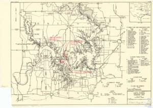
The document is a detailed map produced by the U.S. Army Corps of Engineers, featuring extensive information about areas in Texas and Oklahoma. It includes geographical locations such as Tishomingo, Milburn, Colorado, Kansas, Missouri, and many others. The map also highlights bodies of water like Lake Texoma, Gulf of Mexico, Red River, and Cumberland. It lists wildlife management areas, national wildlife refuges, and various recreation and resort sites. Furthermore, it provides additional data about reservoirs, roads, airports, and project boundaries. The map seems to be part of a larger project by the Corps of Engineers, labeled Albert Maps # 192.
Dates
- Creation: 1957-01-01 - 1970-12-31
Language of Materials
English
Conditions Governing Access:
Certain series of this collection are stored off-site and require prior notice to access. If you wish to view these materials, please contact the Congressional Archives staff to arrange an appointment.
The following series are stored off-site: Clippings, Invitations, Mail, Miscellaneous, Office, and Post Office.
Requests for Office Series: All requests must be made at the folder level and approved by an archivist prior to research. Materials must be reviewed for personally identifiable information and, if needed, appropriately redacted before the researcher is allowed to view them.
Full Extent
1 pages
Abstract
85th (1957-1959); 86th (1959-1961); 87th (1961-1963); 88th (1963-1965); 89th (1965-1967); 90th (1967-1969); 91st (1969-1971)
Repository Details
Part of the Carl Albert Center Congressional and Political Collections Repository