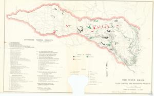
Map of Flood Control and Navigation Projects in the Red River Basin, 1967 March
Scope and Contents
The map provides documentation for various reservoirs, rivers, and flood control projects in the regions of Oklahoma, Texas, Arkansas, and Louisiana. It includes detailed information about the status of projects, such as work completed, authorized, and in progress.
Dates
- Creation: 1967 March
Language of Materials
English
Conditions Governing Access:
Certain series of this collection are stored off-site and require prior notice to access. If you wish to view these materials, please contact the Congressional Archives staff to arrange an appointment.
The following series are stored off-site: Clippings, Invitations, Mail, Miscellaneous, Office, and Post Office.
Requests for Office Series: All requests must be made at the folder level and approved by an archivist prior to research. Materials must be reviewed for personally identifiable information and, if needed, appropriately redacted before the researcher is allowed to view them.
Full Extent
1 pages
Abstract
90th (1967-1969)
Repository Details
Part of the Carl Albert Center Congressional and Political Collections Repository