Broken Bow Lake, Oklahoma Map, undated
Scope and Contents
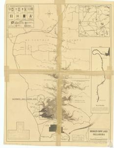
The map of Broken Bow Lake, which is located in McCurtain County, marks the location of the dam, its pools, and nearby roads. The map also includes a key to its navigation aid and marker symbols. The map is undated.
Dates
- Creation: undated
Language of Materials
English
Conditions Governing Access:
Certain series of this collection are stored off-site and require prior notice to access. If you wish to view these materials, please contact the Congressional Archives staff to arrange an appointment.
The following series are stored off-site: Clippings, Invitations, Mail, Miscellaneous, Office, and Post Office.
Requests for Office Series: All requests must be made at the folder level and approved by an archivist prior to research. Materials must be reviewed for personally identifiable information and, if needed, appropriately redacted before the researcher is allowed to view them.
Full Extent
1 pages
Abstract
87th (1961-1963); 88th (1963-1965); 89th (1965-1967); 90th (1967-1969); 91st (1969-1971)
Repository Details
Part of the Carl Albert Center Congressional and Political Collections Repository