Poteau Valley Improvement Authority Water Resource Map, undated
Scope and Contents
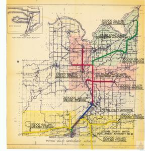
The map of the LeFlore County, Oklahoma area shows the locations of water resources for the Poteau Valley Improvement Authority. The resources are marked on the map, with their respective storage capacity. The map is additionally marked with tape and color.
Dates
- Creation: undated
Language of Materials
English
Conditions Governing Access:
Certain series of this collection are stored off-site and require prior notice to access. If you wish to view these materials, please contact the Congressional Archives staff to arrange an appointment.
The following series are stored off-site: Clippings, Invitations, Mail, Miscellaneous, Office, and Post Office.
Requests for Office Series: All requests must be made at the folder level and approved by an archivist prior to research. Materials must be reviewed for personally identifiable information and, if needed, appropriately redacted before the researcher is allowed to view them.
Full Extent
1 pages
Abstract
87th (1961-1963); 88th (1963-1965); 89th (1965-1967); 90th (1967-1969); 91st (1969-1971)
Repository Details
Part of the Carl Albert Center Congressional and Political Collections Repository