"An Exploration Guide to Outdoor Activities and Landmarks in Oklahoma", 1946-01-01 - 1975-12-31
Scope and Contents
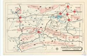
The documentation outlines a map of the area from Fort Smith to Poteau, Oklahoma. It includes various landmarks such as Cavanal Mountain, the highest peak between the Rockies & Alleghanies, and the Quichita National Forest. It also indicates several points of interest including lakes for boating and fishing, scout camps, hunting areas, parks, and a hospital and sanitarium. The map also provides information on the Kiamichi Playgrounds, which offers year-round hunting and fishing. The scale of miles and directions to Paris, Ft. Worth, and Dallas are also included.
Dates
- Creation: 1946-01-01 - 1975-12-31
Language of Materials
English
Conditions Governing Access:
Certain series of this collection are stored off-site and require prior notice to access. If you wish to view these materials, please contact the Congressional Archives staff to arrange an appointment.
The following series are stored off-site: Clippings, Invitations, Mail, Miscellaneous, Office, and Post Office.
Requests for Office Series: All requests must be made at the folder level and approved by an archivist prior to research. Materials must be reviewed for personally identifiable information and, if needed, appropriately redacted before the researcher is allowed to view them.
Full Extent
1 pages
Abstract
79th (1945-1947); 80th (1947-1949); 81st (1949-1951); 82nd (1951-1953); 83rd (1953-1955); 84th (1955-1957); 85th (1957-1959); 86th (1959-1961); 87th (1961-1963); 88th (1963-1965); 89th (1965-1967); 90th (1967-1969); 91st (1969-1971); 92nd (1971-1973); 93rd (1973-1975); 94th (1975-1977)
General
Native Americans
Repository Details
Part of the Carl Albert Center Congressional and Political Collections Repository