
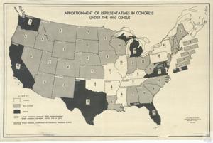
Apportionment of Representatives in Congress Map, 1950 November 07
Scope and Contents
The map of the United States shows changes in apportionment of representatives in Congress based on the 1950 Census. Shading and hatching mark the states with no change or gains in number. The map from November 7, 1950 is attributed to the press reselease by the Department of Commerce on November 2.
Dates
- Creation: 1950 November 07
Language of Materials
English
Conditions Governing Access:
Certain series of this collection are stored off-site and require prior notice to access. If you wish to view these materials, please contact the Congressional Archives staff to arrange an appointment.
The following series are stored off-site: Clippings, Invitations, Mail, Miscellaneous, Office, and Post Office.
Requests for Office Series: All requests must be made at the folder level and approved by an archivist prior to research. Materials must be reviewed for personally identifiable information and, if needed, appropriately redacted before the researcher is allowed to view them.
Full Extent
1 pages
Abstract
81st (1949-1951)
Topical
Repository Details
Part of the Carl Albert Center Congressional and Political Collections Repository