"1947 Road and Mileage Map of the Panama Canal Zone and Vicinity", 1947-01-01 - 1947-12-31
Scope and Contents
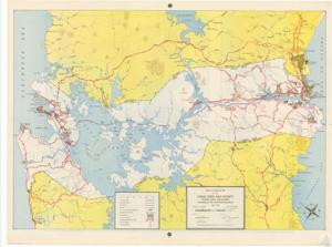
The document describes a detailed map of the Panama Canal Zone and its vicinity, prepared by the Department Engineer in July 1947. It includes various locations such as towns, villages, and military posts, as well as features like roads, railroads, and prominent heights. The map also provides information on surfaced and unsurfaced roads, tractor trails, built-up areas, and mileage between road junctions.
Dates
- Creation: 1947-01-01 - 1947-12-31
Language of Materials
English
Conditions Governing Access:
Certain series of this collection are stored off-site and require prior notice to access. If you wish to view these materials, please contact the Congressional Archives staff to arrange an appointment.
The following series are stored off-site: Clippings, Invitations, Mail, Miscellaneous, Office, and Post Office.
Requests for Office Series: All requests must be made at the folder level and approved by an archivist prior to research. Materials must be reviewed for personally identifiable information and, if needed, appropriately redacted before the researcher is allowed to view them.
Full Extent
1 pages
Abstract
80th (1947-1949)
General
Native Americans
Repository Details
Part of the Carl Albert Center Congressional and Political Collections Repository