"1950 Preliminary Census Figures for Each County in the State of Oklahoma", 1950-01-01 - 1950-12-31
Scope and Contents
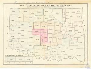
The plan outlines a map of the state of Oklahoma, showing preliminary 1950 census figures for each county. The data ranges from 4,581 in Cimarron County to 322,520 in Oklahoma County. The map is part of the Albut Maps collection, specifically item 75.
Dates
- Creation: 1950-01-01 - 1950-12-31
Language of Materials
English
Conditions Governing Access:
Certain series of this collection are stored off-site and require prior notice to access. If you wish to view these materials, please contact the Congressional Archives staff to arrange an appointment.
The following series are stored off-site: Clippings, Invitations, Mail, Miscellaneous, Office, and Post Office.
Requests for Office Series: All requests must be made at the folder level and approved by an archivist prior to research. Materials must be reviewed for personally identifiable information and, if needed, appropriately redacted before the researcher is allowed to view them.
Full Extent
1 pages
Abstract
81st (1949-1951)
Topical
Repository Details
Part of the Carl Albert Center Congressional and Political Collections Repository