"Comprehensive Map and Legend Details of Ouachita National Forest, Oklahoma", 1964-01-01 - 1964-12-31
Scope and Contents
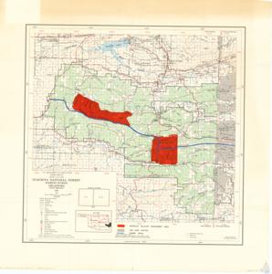
The document describes a detailed map of the Ouachita National Forest in Oklahoma, produced by the U.S. Department of Agriculture Forest Service in 1964. The map includes geographical coordinates, topographical features, township and range lines, and various types of roads and trails. It also depicts important landmarks like triangulation stations, lookout stations, churches, schools, and cemeteries. The map also outlines boundaries of national forest land, intensive wildlife management areas, and other significant areas, and provides locations of district ranger stations, fireman ranger stations, and the Forest Supervisor's Office.
Dates
- Creation: 1964-01-01 - 1964-12-31
Language of Materials
English
Conditions Governing Access:
Certain series of this collection are stored off-site and require prior notice to access. If you wish to view these materials, please contact the Congressional Archives staff to arrange an appointment.
The following series are stored off-site: Clippings, Invitations, Mail, Miscellaneous, Office, and Post Office.
Requests for Office Series: All requests must be made at the folder level and approved by an archivist prior to research. Materials must be reviewed for personally identifiable information and, if needed, appropriately redacted before the researcher is allowed to view them.
Full Extent
1 pages
Abstract
88th (1963-1965)
Repository Details
Part of the Carl Albert Center Congressional and Political Collections Repository