"Detailed Road Classification and Infrastructure Assessment in Oklahoma - 1948", 1950-01-01 - 1950-12-31
Scope and Contents
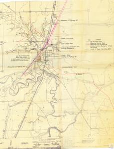
The document describes a map related to the relocation of U.S. Highway 69. It includes details about the Crowder Interchange, the water supply dam, and the relocated county roads. The information also covers the limits of initial backwater effects, elevation details, and the Crowder school. The document mentions the U.S. Army Corps of Engineers in Tulsa, Oklahoma and the Canadian River tributaries in the Arkansas River Watershed. The documentation was submitted in February 1950 and includes a legend, geographic index, and road classifications.
Dates
- Creation: 1950-01-01 - 1950-12-31
Language of Materials
English
Conditions Governing Access:
Certain series of this collection are stored off-site and require prior notice to access. If you wish to view these materials, please contact the Congressional Archives staff to arrange an appointment.
The following series are stored off-site: Clippings, Invitations, Mail, Miscellaneous, Office, and Post Office.
Requests for Office Series: All requests must be made at the folder level and approved by an archivist prior to research. Materials must be reviewed for personally identifiable information and, if needed, appropriately redacted before the researcher is allowed to view them.
Full Extent
1 pages
Abstract
81st (1949-1951)
Repository Details
Part of the Carl Albert Center Congressional and Political Collections Repository