"Comprehensive Map of Watershed Protection and Flood Prevention in Oklahoma", 1959-01-01 - 1959-12-31
Scope and Contents
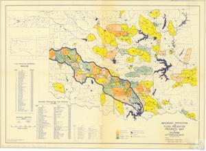
The document is a project map detailing flood prevention watersheds in Oklahoma, created by the U.S. Department of Agriculture's Soil Conservation Service. It provides information on watershed protection and flood prevention, including details of the drainage area, counties involved, construction progress, and existing or planned constructions. The map, which has been checked and approved both cartographically and technically, was last revised in July 1959.
Dates
- Creation: 1959-01-01 - 1959-12-31
Language of Materials
English
Conditions Governing Access:
Certain series of this collection are stored off-site and require prior notice to access. If you wish to view these materials, please contact the Congressional Archives staff to arrange an appointment.
The following series are stored off-site: Clippings, Invitations, Mail, Miscellaneous, Office, and Post Office.
Requests for Office Series: All requests must be made at the folder level and approved by an archivist prior to research. Materials must be reviewed for personally identifiable information and, if needed, appropriately redacted before the researcher is allowed to view them.
Full Extent
1 pages
Abstract
86th (1959-1961)
Repository Details
Part of the Carl Albert Center Congressional and Political Collections Repository