"Mapping the Red River Watershed: An Overview of Engineering Projects in Oklahoma and Arkansas by the U.S. Army Corps of Engineers", 1951-01-01 - 1951-12-31
Scope and Contents
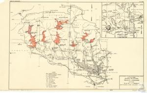
This project documentation is a detailed map by the U.S. Army Corps of Engineers, illustrating specific geographical locations, water bodies, mountains, and dam sites in areas of Oklahoma and Arkansas. The map includes elements such as watershed divides, river miles, federal highways, state highways, as well as information about overflow limits and conservation pools. The document also provides scale of miles, and highlights projects considered within these areas, dating back to August 1951.
Dates
- Creation: 1951-01-01 - 1951-12-31
Language of Materials
English
Conditions Governing Access:
Certain series of this collection are stored off-site and require prior notice to access. If you wish to view these materials, please contact the Congressional Archives staff to arrange an appointment.
The following series are stored off-site: Clippings, Invitations, Mail, Miscellaneous, Office, and Post Office.
Requests for Office Series: All requests must be made at the folder level and approved by an archivist prior to research. Materials must be reviewed for personally identifiable information and, if needed, appropriately redacted before the researcher is allowed to view them.
Full Extent
1 pages
Abstract
82nd (1951-1953)
Repository Details
Part of the Carl Albert Center Congressional and Political Collections Repository