"Map and Directory of Le Flore and McCurtain Counties, Oklahoma", 1945-01-01 - 1966-12-31
Scope and Contents
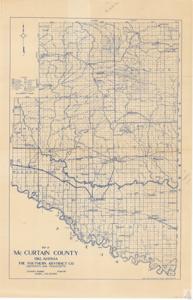
The document is a detailed map of Le Flore County and McCurtain County in Oklahoma, produced by The Southern Abstract Co. It includes a legend indicating U.S. highways, state highways, railroads, paved roads, gravel roads, marshes, graded and county roads, schools, minor roads, proposed roads, and trails. The map also highlights various towns and landmarks within the counties, such as Beachton, Smithville, Burley, Watson, Plunrettville, Battiest, Pickens, Tab Bethel, and more. The map was made by J.G. Hendrix, President of The Southern Abstract Co., and printed by the Gallup Map Stationery Co. in Kansas City, Missouri.
Dates
- Creation: 1945-01-01 - 1966-12-31
Language of Materials
English
Conditions Governing Access:
Certain series of this collection are stored off-site and require prior notice to access. If you wish to view these materials, please contact the Congressional Archives staff to arrange an appointment.
The following series are stored off-site: Clippings, Invitations, Mail, Miscellaneous, Office, and Post Office.
Requests for Office Series: All requests must be made at the folder level and approved by an archivist prior to research. Materials must be reviewed for personally identifiable information and, if needed, appropriately redacted before the researcher is allowed to view them.
Full Extent
1 pages
Abstract
79th (1945-1947); 80th (1947-1949); 81st (1949-1951); 82nd (1951-1953); 83rd (1953-1955); 84th (1955-1957); 85th (1957-1959); 86th (1959-1961); 87th (1961-1963); 88th (1963-1965); 89th (1965-1967)
Repository Details
Part of the Carl Albert Center Congressional and Political Collections Repository