"U.S. Army Corps of Engineers: Map and Data of Hugo Reservoir and Red River Watershed, Oklahoma (1957)", 1957-01-01 - 1957-12-31
Scope and Contents
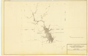
The document is a map or project documentation by the U.S. Army Corps of Engineers, dated November 1957. It details the Hugo Reservoir (Sawyer Site) in Oklahoma, including geographical coordinates and pool elevations. It also covers details of the Red River Watershed and Kiamichi River. The document, marked as preliminary and subject to revision, is part of the Albert General Boy 13 Folder 20 (Maps F2 Item 47).
Dates
- Creation: 1957-01-01 - 1957-12-31
Language of Materials
English
Conditions Governing Access:
Certain series of this collection are stored off-site and require prior notice to access. If you wish to view these materials, please contact the Congressional Archives staff to arrange an appointment.
The following series are stored off-site: Clippings, Invitations, Mail, Miscellaneous, Office, and Post Office.
Requests for Office Series: All requests must be made at the folder level and approved by an archivist prior to research. Materials must be reviewed for personally identifiable information and, if needed, appropriately redacted before the researcher is allowed to view them.
Full Extent
1 pages
Abstract
85th (1957-1959)
Repository Details
Part of the Carl Albert Center Congressional and Political Collections Repository