Watershed Protection and Flood Prevention Progress Map of Oklahoma, 1959 July
Scope and Contents
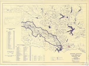
This map, made by the U.S. Department of Agriculture, marks the progress of water resource projects in Oklahoma. The map is based on the 1953 U.S. Geological Survey Map of Oklahoma and was created 1957 October 28, revised 1959 July.
Dates
- Creation: 1959 July
Language of Materials
English
Conditions Governing Access:
Certain series of this collection are stored off-site and require prior notice to access. If you wish to view these materials, please contact the Congressional Archives staff to arrange an appointment.
The following series are stored off-site: Clippings, Invitations, Mail, Miscellaneous, Office, and Post Office.
Requests for Office Series: All requests must be made at the folder level and approved by an archivist prior to research. Materials must be reviewed for personally identifiable information and, if needed, appropriately redacted before the researcher is allowed to view them.
Full Extent
1 pages
Abstract
86th (1959-1961)
Repository Details
Part of the Carl Albert Center Congressional and Political Collections Repository