"Geographical Data and Distances in Oklahoma", 1945-01-01 - 1966-12-31
Scope and Contents
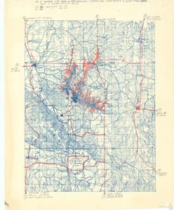
The document is a project map detailing three streams at various elevations, with a noted correction from the original. It also provides distances between various locations, such as Oklahoma City, Ada, Shawnee, Tulsa, Duncan, Atoka, Ardmore, Dallas, Madill, Fort Worth, and Durant. The map includes other specific details and landmarks, such as U.S. 10 and U.S. 77. Removed from a brochure on proposed Rock Creek Dam, 1956 file. Map is annotated and hand- colored.
Dates
- Creation: 1945-01-01 - 1966-12-31
Language of Materials
English
Conditions Governing Access:
Certain series of this collection are stored off-site and require prior notice to access. If you wish to view these materials, please contact the Congressional Archives staff to arrange an appointment.
The following series are stored off-site: Clippings, Invitations, Mail, Miscellaneous, Office, and Post Office.
Requests for Office Series: All requests must be made at the folder level and approved by an archivist prior to research. Materials must be reviewed for personally identifiable information and, if needed, appropriately redacted before the researcher is allowed to view them.
Full Extent
1 pages
Abstract
79th (1945-1947); 80th (1947-1949); 81st (1949-1951); 82nd (1951-1953); 83rd (1953-1955); 84th (1955-1957); 85th (1957-1959); 86th (1959-1961); 87th (1961-1963); 88th (1963-1965); 89th (1965-1967)
Topical
Repository Details
Part of the Carl Albert Center Congressional and Political Collections Repository